Waterfalls Near Killington
Vermont's Green Mountains hide some of New England's most beautiful waterfalls, and many are an easy drive from The Killington Chalet. From roadside cascades you can reach in minutes to gorge hikes worth the trip, here are 16 of our favorite falls — with photos, driving directions, and tips on when to visit.
Near Killington (within ~1 hour)
Thundering Falls — Killington, ~5–10 min

At 140 feet, Thundering Falls is said to be the sixth-tallest waterfall in Vermont. Kent Brook — flowing out of Kent Pond — tumbles through a steep, narrow cataract, most dramatic at high water in spring, on the site of a historic mill. This is a viewing-only stop (no swimming); the draw is how easy it is to reach, including the first universally accessible section of the Appalachian Trail in Vermont.
Getting there: From the VT-100 / VT-4 junction in Killington, drive 2 miles east and turn left onto
River Road; continue 1.5 miles to the accessible parking lot on the left (2295 River Rd). Follow the 900-foot boardwalk across the Ottauquechee River floodplain, then a short switchback path to the viewing
platform. About 0.5 miles out and back — easy and wheelchair/stroller friendly. Best season: Spring for peak flow; the trail is typically hikable March–October (not maintained in winter).
Buttermilk Falls — Ludlow · 20–25 min

A cluster of three waterfalls along Branch Brook near Okemo State Forest, and one of southern Vermont's classic swimming holes. The 20-foot middle falls drops into a deep, clear pool big enough for full submersion, and the upper falls has the best jumping rocks. Expect crowds on hot summer weekends; the rocks are slippery, so water shoes are a good idea.
Getting there: From Ludlow, take VT-100 north, turn left onto VT-103, drive about 1.5 miles, then turn right onto Buttermilk Falls Road and follow it to the end. The falls are a very short walk from the road, with paths to the lower, middle, and upper sections.
Best season: Summer for swimming; spring for the strongest flow.
Texas Falls — Hancock · 40–50 min

A series of pothole-plunge cascades dropping about 35 feet over a hundred-yard stretch through a narrow, steep gorge in the Green Mountain National Forest — one of the most photographed waterfalls in Vermont. A footbridge near the parking area gives an easy bird's-eye view, and a ~1-mile nature trail loops through the woods with additional overlooks. Swimming is prohibited near the falls; there is wading near the upstream picnic area.
Getting there: From Hancock village, take VT-125 West for about 3 miles, turn right onto Forest Road 39 (Texas Falls Road, well signed) and go 0.5 miles to the recreation area parking. The main falls are visible from the bridge by the lot; the ~1.2-mile nature trail loop takes 30–60 minutes and is easy. Note: the gate on Forest Road 39 closes in winter.
Best season: Spring and early summer for flow; spectacular in fall foliage.
Quechee Gorge - Quechee · 40–45 min

Vermont's deepest gorge, carved by glacial meltwater — the gorge itself is the draw here, a 165-foot-deep chasm spanned by the US-4 bridge with overlooks. At the head of the gorge, Mill Pond Falls cascades at the Quechee Dam; it's a modest, dam-related cascade rather than a backcountry waterfall. Best as a combined stop: walk the gorge trail, visit the falls at the dam, and watch for raptors riding the updrafts.
Getting there: Quechee Gorge State Park, off US-4 in Quechee. Park at the state park or the visitors center; the gorge trail runs along the rim and down to the river at the gorge base, with views of the falls near the dam at the gorge head.
Best season: Year-round viewpoint; spring for the strongest river flow. Foliage season is spectacular but busy.
Warren Falls — Warren · 50–55 min

Warren Falls — Warren · 50–55 min
Vermont's beloved natural water park — a series of small cascades on the Mad River dropping into crystal-clear emerald pools surrounded by smooth granite and gorge walls. Natural rock slides, wading pools, and cliff-jumping ledges (10-, 15-, and 20-foot spots) draw summer crowds, and Yankee Magazine once named it a top-10 U.S. swimming hole. Expect company on hot weekends; go early or on a weekday.
Getting there: 3919 Vermont Route 100, Warren — small signed parking lot on the east side of VT-100 just south of Warren village. A short, easy path leads down to the riverbed and pools. Free, no facilities; limited parking.
Best season: Summer for swimming (water stays cold even in August). Beautiful in fall and striking partially frozen in winter.
Near Killington (Over 1 hour away)
Moss Glen Falls (Granville) — Granville · 50–60 minA 35-foot horsetail

Moss Glen Falls (Granville) — Granville · 50–60 minA 35-foot horsetail cascade along Deer Hollow Brook, right off scenic VT-100 in the Granville Gulf. The falls pour over moss-covered rock into a clear pool, viewed from an observation platform at the end of a very short, easy trail — an ideal quick roadside stop on a Route 100 drive. Viewing only; swimming is prohibited.
Getting there: Park at the signed pull-off on VT-100 (about 8015 VT-100, roughly 3 miles south of Granville village). Cross the small wooden bridge and follow the level gravel path about 0.1–0.2 miles to the viewing deck.
Best season: April–November; spring for the best flow.
Falls of Lana — Salisbury · 60–70 min

A series of cascades and pools on Sucker Brook in the Green Mountain National Forest, just south of Branbury State Park and Lake Dunmore, with roughly 100 vertical feet of visible drop. The upper falls feed a turquoise swimming hole popular on summer days. The trailhead is shared with the Silver Lake Trail, and the Rattlesnake Cliffs overlook makes a good add-on hike. Footing near the falls can be steep and slippery.
Getting there: From Forest Dale, travel north on VT-53 for 5.2 miles to the large Silver Lake / Falls of Lana parking area. The lower-falls viewpoint is less than half a mile in on the easiest trail; the upper falls and swimming hole are about another half mile.
Best season: April–November for hiking; summer for swimming.
A sequence of cascades and horsetail falls dropping a combined 80–85 feet on the outlet stream of Abbey Pond, on the flanks of the Hogback in the Green Mountain National Forest. The upper falls are visible from a footbridge a short way up the Abbey Pond Trail. It's a quieter, lesser-known stop. Keen hikers can continue 1.8 miles further to Abbey Pond (4.2 miles round trip, moderate).
Getting there: Abbey Pond Road, a narrow dirt road, turns east off VT-116 about 1 mile south of the Bristol–Middlebury town line; follow it to the dead end and park. The cascades are about 0.2–1.0 miles up the Abbey Pond Trail.
Best season: Spring for flow; the trail is open year-round.
North to Stowe
Moss Glen Falls (Stowe) — Stowe · ~1 hr 25 min
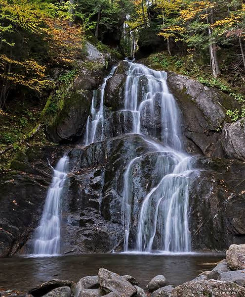
One of Vermont's most photographed waterfalls — the brook fans out over a wide, moss-covered ledge in two main drops inside C.C. Putnam State Forest. An easy quarter-mile boardwalk trail through the woods leads to a short, steep scramble up to the base, where the falls fill the whole frame. Viewing only — a look-and-photograph spot, not a swimming hole.
Getting there: From Stowe center, head north on VT-100 ~3 miles, turn right onto Randolph Road, go 0.5 mile, then right onto Moss Glen Falls Road; the trailhead parking is 0.5 mile on the left. The final section is steep and can ice over in winter.
Best season: Spring for the most dramatic flow after snowmelt; October for foliage framing the falls.
Bingham Falls — Stowe · ~1 hr 30 min

A powerful 30-to-40-foot plunge into a water-sculpted gorge on the West Branch Waterbury River — named Vermont's best waterfall by Travel + Leisure in 2026. The falls crash into a deep, cold pool flanked by gorge walls, and the short hike in passes smaller cascades and swimming holes. Adventurous swimmers cool off in the pool at their own risk on slippery rocks; foliage-season visitors get one of Vermont's classic waterfall views.
Getting there: Trailhead parking on both sides of VT-108 (Mountain Road) a few miles north of Stowe village toward Smugglers' Notch. The falls trail is about a quarter to a half mile one way — the final descent to the base is steep and slippery, so wear good shoes.
Best season: Summer for swimming and the full experience; fall for foliage.
Sterling Falls Gorge — Stowe · ~1 hr 35 min

Pikes Falls — Jamaica · ~1 hr

A Stowe Land Trust–conserved gorge trail through Page Forest following Sterling Brook down a rocky ravine — an interpretive walk past three named falls, six cascades, and eight deep pools rather than one single big drop. It's the quietest pick in this guide: a moderate, rooty trail with a ladder section, benches, and signage explaining the gorge's natural history. Viewing only.
Getting there: Trailhead at ~3990 Sterling Valley Road (Sterling Gorge Road), Stowe — small lot, free, no permits required. Expect roots, rocks, elevation change, and a ladder section — moderate difficulty, roughly an hour round trip.
Best season: Late spring through early fall.
A hidden gem of a swimming hole rather than a big dramatic cascade — Kidder Brook tumbles about 20 feet in two gentle stages into one of Vermont's largest natural swimming pools, roughly 40 by 25 feet and up to 10 feet deep. The smooth rock beside the falls acts as a natural water slide, and a flat rocky beach lines the pool's edge, making it a favorite family summer spot.
Getting there: From VT-100 in Jamaica, turn onto Pikes Falls Road and drive about 5 miles to the informal dirt pull-off near Day Road. An easy 300-foot path leads down to the falls — about 5–10 minutes on foot.
Best season: Summer, when the water is swimmable (still brisk).
Hamilton Falls — Jamaica · ~1 hr

One of Vermont's tallest and most celebrated waterfalls — Cobb Brook cascades roughly 125 feet down a mountainside in a series of horsetails and slides into a deep gorge, carving unusual potholes in the bedrock. It's a look-don't-swim falls: the pools are deceptively dangerous and posted against swimming. The scenic West River rail-trail approach makes the trip as rewarding as the destination.
Getting there: Main approach is from Jamaica State Park (48 Salmon Hole Ln, Jamaica; day-use fee, open Memorial Day–Columbus Day). Hike the flat West River Trail 2 miles, then turn uphill on the Hamilton Falls Trail for the final ~1.1 miles — about 6 miles round trip, moderate, ~2.5 hours.
Best season: Spring and early summer for the strongest flow; spectacular in fall foliage.
Angel Falls — Windham (via Jamaica) · ~1 hr

A quieter, lesser-known 25-foot horsetail falls that splits into two segments around a central rock outcrop as it drops over exposed granite ledges. A small plunge pool at the base is big enough for a refreshing dip, and a picturesque stone bridge just downstream makes a great photo vantage. Pairs nicely with a stop at Ball Mountain Dam for panoramic views of Stratton and Bromley.
Getting there: Park at the Angel Falls trailhead picnic area with gazebo on Ball Mountain Lane (88 Ball Mountain Lane, Jamaica). Hike about 1.3 miles on the West River Trail to the falls — easy-to-moderate. Note the dam access road hours: open daily 8 a.m.–8 p.m. from the third Saturday in May through Columbus Day weekend.
Best season: Spring for the fullest flow; fall for foliage.
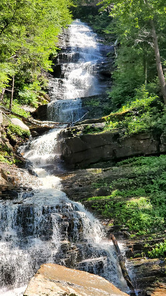
One of the tallest waterfalls in Vermont at roughly 125 feet, tucked deep in the 18,000-acre Lye Brook Wilderness. The reward at the end of a 4.5-mile round-trip hike is a dramatic cascade roaring down a rock face — gorgeous in high water, sometimes reduced to a trickle in dry summers. Wear sturdy, waterproof footwear; expect rocky terrain, roots, and stream crossings.
Getting there: Trailhead at the end of Glen Road in Manchester (free parking). Follow the blue-blazed Lye Brook Falls Trail — 4.5 miles round trip, moderate, about 2.5–3 hours.
Best season: Spring for thundering flow; fall for peak foliage along the wilderness trail.
Lye Brook Falls — Manchester · ~1 hr 15–30 min
Worth the Drive Big Falls of the Missisquoi — Troy / North Troy · ~3.5–4 hrs each way
